What is the wind speed and direction?
Wind is a physical quantity that represents the movement of air currents. It has both a numerical magnitude (wind speed) and a direction (wind direction). Wind speed is a measure of the horizontal distance the wind travels per unit of time. The units are often expressed in m/s, knot (nautical miles per hour, also known as “knots”,) and km/h. Wind direction is the direction in which the wind is blowing. Wind direction at ground level is expressed in 16th, while wind direction at high altitude is often expressed in degrees of azimuth (0-360°).
According to the phenomenon caused by the wind on the ground, the size of the wind is categorized into 12 grades, which are called wind levels. People usually hear “East Wind Level 3” in weather forecasts, which refers to the “Beaufort Wind Level”. This is the British Beaufort (Francis Beaufort) in 1805, according to the wind on the ground (or sea) objects affect the degree of wind grade, a total of 0 ~ 17 levels.
| Wind Scale | Name of the Wind | Wind Speed(m/s) | Wind Speed(km/h) | Conditions on Land | Sea Surface Condition |
|---|---|---|---|---|---|
| 0 | Calm | 0~0.2 | <1 | Quiet | Calm |
| 1 | Light air | 0.3~1.5 | 1~5 | Smoke show wind direction | Slight waves |
| 2 | Light breeze | 1.6~3.3 | 6~11 | The leaves sway gently | Small waves |
| 3 | Gentle breeze | 3.4~5.4 | 12~19 | Flags flying | Small waves |
| 4 | Moderatebreeze | 5.5~7.9 | 20~28 | The twigs of the tree sway | Light waves |
| 5 | Fresh breeze | 8.0~10.7 | 29~38 | The water surface on land has ripples | Medium waves |
| 6 | Strong breeze | 10.8~13.8 | 39~49 | Difficulty holding an umbrella | Large waves |
| 7 | Moderategale | 13.9~17.1 | 50~61 | Difficulty walking into the wind | Billow |
| 8 | Fresh gale | 17.2~20.7 | 62~74 | Small branches will break off | Strong waves |
| 9 | Strong gale | 20.8~24.4 | 75~88 | Roof tiles destroyed | Raging waves |
| 10 | Whole gale | 24.5~28.4 | 89~102 | Damage to buildings | Raging waves |
| 11 | Storm | 28.5~32.6 | 103~117 | Severe damage to buildings | Storm surge |
| 12 | Hurricane | 32.6~36.9 | 118~133 | Highly destructive | Storm surge |
| 13 | Typhoon | 37.0~41.4 | 134~149 | Highly destructive | Tsunamis |
| 14 | Strong Typhoon | 41.5~46.1 | 150~166 | Highly destructive | Tsunamis |
| 15 | Strong Typhoon | 46.2~50.9 | 167~183 | Highly destructive | Tsunamis |
| 16 | Super Typhoon | 51.0~56.0 | 184~202 | Bring devastating damage | Large Tsunamis |
| 17 | Super Typhoon | ≥56.1 | ≥203 | Bring devastating damage | Mega Tsunamis |
What affects wind speed and direction?
Wind speed and direction are affected by three forces: the horizontal pressure gradient force, the geostrophic bias force and the friction force. Horizontal pressure gradient force affects the wind speed and initial direction, friction force affects the wind speed (weakening effect), and geostrophic deflection force affects the wind direction after the wind is generated.
In addition to these three forces, wind speed and direction are affected by topography, temperature, human activity and meteorology. Differences in temperature can lead to differences in air pressure, which affects wind speed and direction. Urban buildings can significantly alter localized wind speed and direction. Meteorological factors such as low pressure systems, high pressure systems, cold fronts and warm fronts can also significantly affect wind speed and direction.
What is the relationship between wind speed and wind direction?
Although the definitions of wind speed and wind direction are different, their relationship affects each other. If the wind speed is greater, then the change in wind direction is more pronounced, and conversely, frequent changes in wind direction affect the wind speed. With data on wind speed and direction, meteorologists can gain a comprehensive understanding of air movement in the atmosphere and accurately predict and analyze wind behavior.
The relationship between wind speed and direction is usually influenced by geography and meteorology and varies together. For example, when the wind encounters a mountain range blocking its movement, it not only weakens the wind speed, but also changes the wind direction. In extreme weather conditions, both wind speed and direction can change rapidly. So when encountering external effects, wind speed and direction tend to change together.
Therefore, for many fields, such as marine aviation, weather forecasting, environmental monitoring and agricultural production. It is necessary to monitor the wind speed and direction at the same time. In this way, accurate judgment can be made.
What device measures wind speed and direction?
1. Portable anemometer
The pressure sensor and the temperature sensor are the two main components of a portable anemometer. The pressure sensor calculates the wind speed by measuring the difference in static pressure generated by the air flow. In addition, wind speed and temperature are closely related, and changes in temperature affect the density of the air, which in turn affects the measurement of wind speed.
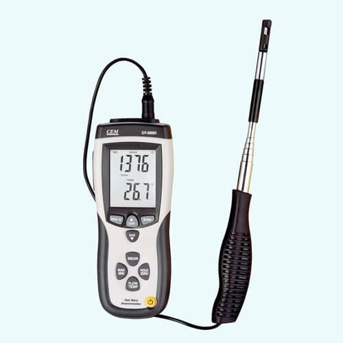
Specifically, flowing air passes through a small hole in the anemometer, and the wind speed is converted by measuring the pressure difference created at each end of the hole. As the wind blows through the small hole, the stronger the wind speed, the greater the pressure difference between the two ends of the small hole, and the greater the final measured wind speed value. Built-in advanced sensors can measure even small differences and quickly convert them into electrical signals.
2. Wind speed and direction sensor
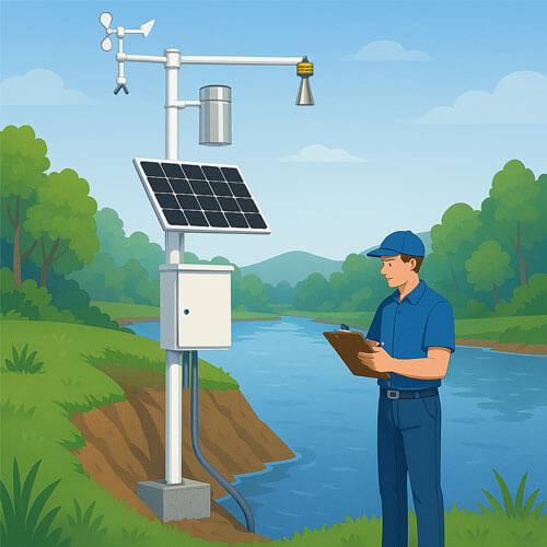
The most widely used wind speed and direction sensor is three-cup wind speed sensor and wind vane sensor. They are mechanical. They are inexpensive and have accurate measurement data. The structure of the three-cup wind speed sensor usually consists of three evenly distributed cups, a center shaft, and a tachometer. The wind speed is converted into an electrical signal by the sensor module, which finally outputs the wind speed value.
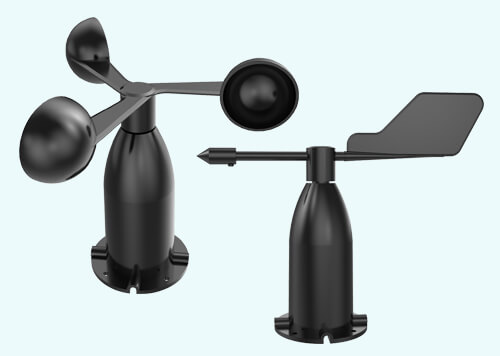
The wind direction sensor detects and senses the external wind direction information by the rotation of the wind arrow, and transmits it to the coaxial code disk, and outputs the numerical value corresponding to the wind direction at the same time. Usually, the body of the wind direction sensor adopts the mechanical structure of the wind vane, when the wind blows towards the tail of the wind vane, the arrow of the wind vane will point to the direction of the wind blowing over.
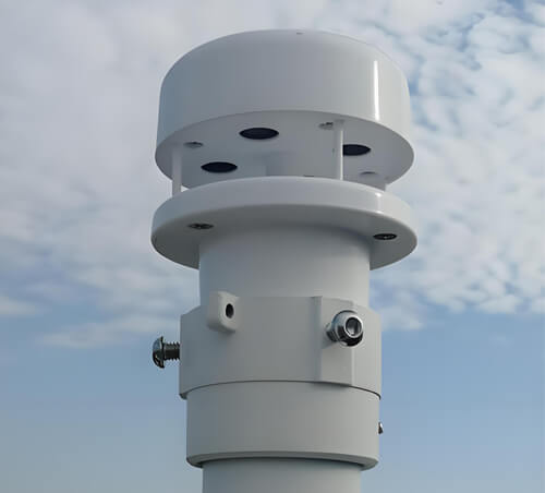
3. Ultrasonic anemometer
Ultrasonic anemometer is a more advanced instrument for measuring wind speed and direction. It utilizes the emitted acoustic pulse at the receiving end to measure the time or frequency (Doppler shift) difference to calculate the wind speed and direction. It can work normally for a long time because it overcomes the inherent defects of mechanical wind speed and direction meters. The ultrasonic wind speed and direction sensor adopts an integrated design and is lightweight, so it does not require frequent maintenance and calibration, and can output wind speed and direction stably. Customers can choose the unit of wind speed, output frequency and output format according to their needs.
4. Satellite remote sensing equipment
Satellite remote sensing technology can infer information such as wind speed and direction by monitoring features such as gases and cyclones in the atmosphere. The direction and speed of cloud movement can represent wind direction and speed. Small areas of cumulus clouds are usually chosen as tracers of low-altitude winds and small areas of cirrus clouds as tracers of high-altitude winds. The height of the cloud is determined by the temperature of the infrared cloud map; the lower the temperature, the higher the height. By utilizing this method a lot of information on low and high level winds over the front can be obtained.
FAQs about wind speed and direction
High-pressure environments have low wind ratings. In low-pressure environments, strong winds, hurricanes, etc. are likely to occur.
Wind shear is an atmospheric phenomenon that refers to changes in wind direction and speed over horizontal or vertical distances in the air. Wind shear is an important factor leading to flight accidents, especially low-level wind shear on the aircraft takeoff and landing threat is huge.
- Blocked by mountains: When the terrain is high, the prevailing winds are blocked by mountains and the wind speed decreases. The terrain is flat, the prevailing winds are long-drawn, and the wind speed is high.
- Narrow tube effect: Located at the mouth of a valley (or inside a valley), the canyon and the prevailing winds are in the same direction. It is easy to form a narrow tube effect, wind speed is enhanced.
- Headland effect: located in the headland, easy to form the headland effect, wind speed enhancement.
Since water vapor is the primary condition for rainfall and snowfall, and water vapor is transported by wind, observing wind direction can predict weather changes. In addition, wind speed and direction can change the distribution of heat between the surface and the atmosphere, thus regulating the temperature.
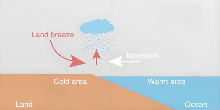
The sea is slow to heat up due to its thermal properties. The temperature above is relatively cold, and cold air sinks and flows near the surface to the nearby hotter land surface, replenishing the gap caused by the rising hot air and forming sea breezes.
The wind blowing from the ocean to the land during the day is called the sea breeze. Winds blowing from the land to the sea at night are called land winds.
According to the wind blowing on the ground or water objects produced by various phenomena, the size of the wind is divided into 13 levels, the smallest is 0, the largest 12. Detailed wind level sheets.
Commonly used wind speed units include meters per second (m / s), kilometers per hour (km / h) and miles per hour (mph). Wind speed at sea is sometimes measured in knots (1 knot = 1.852 km/h).
Buildings in cities are clustered and of different heights and sizes. This increases the resistance to wind flow, so wind speeds are generally lower in cities than in the suburbs.
Cold fronts are formed by cold air actively pushing into warm air, forcing the warm air to rise. In the Northern Hemisphere, winds are generally northerly at the back of cold fronts, and generally southwesterly or southerly at the front of cold fronts.
Vegetation slows down wind speeds, and the higher the vegetation cover, the lower the wind speeds. Flat, open plains or desert areas are more windy.

